Navin
Walk with us everywhere
Navin developed the first indoor navigation platform that overcomes the lack of GPS signals in buildings, by turning every smartphone into a real-time mapping device. Navin already provides its services to venues in Israel and Europe
128% of funding target

By: Daniel Ouanounou
 Successfully fundedAngel Investment

Investment type:
Company Stage:
Category:
Software
Highlights
Highlights
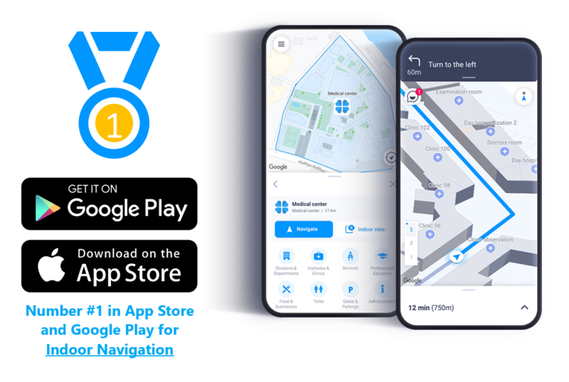
Navin Starts Where Google Maps Ends
Navin has developed the world's first indoor and outdoor navigation app. The platform provides a seamless transition from the outside in (and vice versa), locates its users accurately anywhere in the world, and helps them navigate and plan their route from end to end. With tens of thousands of downloads and millions of square meters already mapped out thus far, the app provides an innovative navigation experience that helps users arrive at their destination on time and without complications.
A Revolutionary Technology that Maps any Building Using Only Smartphones
Navin's unique platform converts smartphones into independent and anonymous self-mapping devices, thanks to a crowd-mapping approach, which has never been seen in this market. Thus, the company delivers value in millions of public venues, that other solutions can't reach.
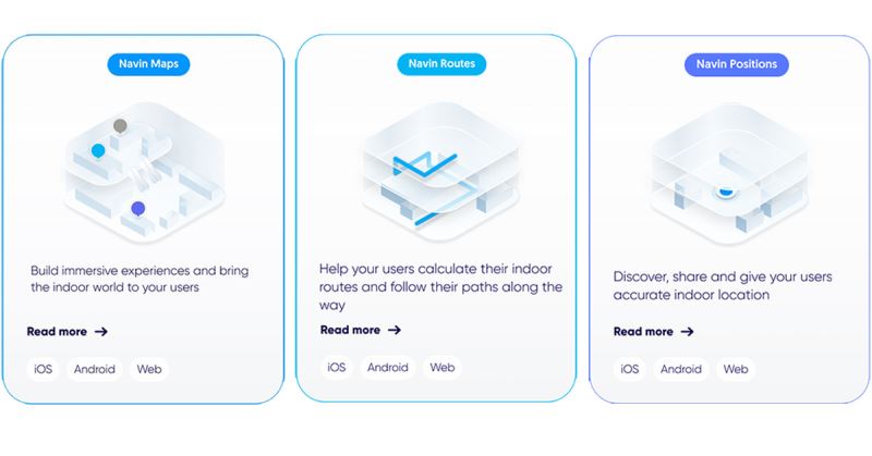
Location-Based Services "for the Last Mile"
Navin allows business owners (shopping malls, hotels, hospitals, campuses, and more) to produce insights from indoor traffic, that will help optimize operations and maximize revenues. With services like accurate indoor positioning, visitors' route analysis, and proximity marketing, the company provides Location Based Services (LBS), similar to Google Maps—that cover the outdoor market only. Furthermore, every delivery, logistics, or workforce management enterprise that utilizes LBS, will enjoy Navin's platform to enhance the user experience within buildings.
Investments from International VCs and Participation in Prestigious Accelerators
Navin has raised substantial investments from SIBF and Sherpa Innoventures VCs—that financially and strategically invested in startup companies with a unique tech vision, and succeeded in numerous investments and exits in Israel. Moreover, the company has raised significant investment from the Swiss SCS company (with offices in western Europe and Dubai, and provides business development consultations) and participation in prestigious accelerators- Microsoft Ventures, 8200 EISP, and LA Fusion.

Approved Patents in Europe and the US
Navin has approved patents in Europe and the US that protect its ability to create digital signal maps via smartphones only, enabling indoor and outdoor navigation as well as Location Based Services.

Navin's Customers: Hospitals and Universities Around Israel, Dan Hotels, and Get Package
Numerous enterprises and venues have already joined Navin's platform and are enjoying a variety of navigation and positioning services. Among the company’s customers are Rambam Hospital, Ariel University, Shaare Zedek Medical Center, Hillel Yaffe Medical Center, Yoseftal Hospital, Soroka Hospital, Hadassah Ein Kerem, Dan Hotels, Get Package (an international delivery company), Real-Time (an international staff management company) and Rehau (industrial facilities management company in western Europe). Via the crowd-mapping technology, up-to-date maps are automatically added to the platform on a daily basis, based on information provided by the company's customers' users.
.png)
Pitch
Pitch
Indoor GPS
When we are navigating outdoors, our smartphones receive continuous feedback from GPS signals. However, once we step inside a building, these signals are no longer available, rendering GPS-based solutions useless. This is the GPS Gap. We spend over 85% of our time and money indoors, in malls, office buildings, hospitals, airports, universities, etc…Nowadays, in order to find our way around a building and plan our route, venues utilize designated hardware (beacons, routers, and other devices), which they install on walls, along with conducting manual mapping of the entire building. This results in an outdated, slow and unscalable approach—with substantial maintenance and installation expenses—and mandates an improved solution to address the millions of public venues worldwide.
The Location-Based Services Market
Location Based Services (LBS) refer to services provided based on users' location which is determined by their smartphones' geographic input. LBS apps deliver services and information to users based on their specific location. The LBS market offers countless apps that utilize outdoors-only LBS:
- Maps and Navigation: Maps, routes, and navigation services (Google Maps)
- Localization Services: Mobile device tracking (Find My Phone), family members localization (360Life)
- Information Services: Finding contacts in the area (Yelp), content created by users
- Apps: Marketing, social media (TikTok)

The demand for such services has grown tremendously due to technological advancements and dependency on the completion of everyday tasks.
Crowd-Mapping
Crowd-mapping technologies have experienced tremendous growth in the past few years, with apps such as Waze and Moovit leveraging their entire operational model. This approach allows an automatic collection of data by a large group of users, without any external intervention or investment of resources. In this manner, enterprises can collect data—which is updated in real-time—that helps them deliver their services more efficiently (traffic report on a particular road or the exact location of a specific bus in real-time, for example).

The Need
While GPS-based technologies are rapidly expanding, with many platforms utilizing LBS for their own business needs, the Indoor GPS realm—which provides LBS and maps for indoor venues—is at a standstill. Technological platforms and businesses can gain tremendous value from indoor geo-data, along with the general public, who is in need of a navigation and wayfinding solution within complex buildings.
The Indoor GPS field encounters many challenges that alter its development, including the need for expensive hardware installation, extensive maintenance, and manual mapping of every building. The result is slow and expensive, with no real-time information and no deployment scalability.
![]()
The Solution
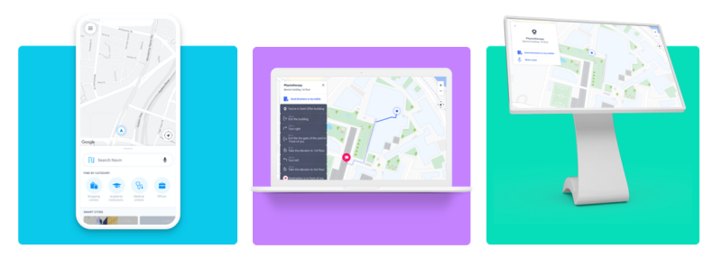
Navin's Indoor GPS platform is a 360 degrees solution—a software delivering end-to-end mapping, positioning, and navigation services, both indoors and outdoors. Via a patent-protected algorithm that converts data collected automatically by smartphones to geographic information, the platform efficiently maps indoor spaces, without any hardware installation. Additionally, the company uses the crowd-mapping approach, thus transforming users' smartphones into anonymous indoor mapping devices, that can easily create real-time maps. This enables the company to continuously add more and more maps to the platform, from anywhere in the world.
With this revolutionary technology, visitors in hospitals, hotels, airports, shopping malls, and museums can enjoy the most accurate orientation experience, by using a mobile app displaying easy-to-read digital maps. Alongside, enterprises and app developers can become more efficient and provide LBS indoors, such as:
- Shopping malls can provide indoor navigation and location-based marketing and conduct different analyses of visitor traffic.
- Food and package delivery companies can minimize delivery time by over 15% and maximize their profits.
- Workforce management companies can improve their operations and save over 20% on their staff expenses.
The platform is suitable for different operating systems (iOS, Android, Web) and allows enterprises to subscribe or integrate it within their own applications.
The Technology
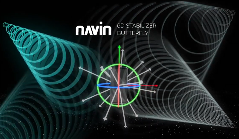
Navin's revolutionary technology automatically maps venues using smartphones only. In fact, the smartphone takes on the role of GPS satellites, and continuously records data via existing smartphone sensors. This data is then translated into geographic and localization information (maps) by the company’s distinctive algorithm.
Navin's algorithm collects electromagnetic signals and the general movement in buildings using smartphones only. These primary signals are processed by the company's proprietary technology, and the output obtained is in the form of accurate positioning data within the building, down to a specific floor or room. In this manner, an accurate map of different public venues is created, without the use of any designated hardware, maintenance or special permits.
Clients in POC
Several new potential customers are currently engaged with Navin on Proof-of-Concept projects; in particular CWS (German company, leader in logistics and maintenance operations for large facilities in central Europe), WearIn (Swiss company specialized in safety operations, working with firefighters, law enforcement and mission-critical operators in Europe and UAE), Meckano (Israeli company with worldwide operations and providing HR solutions and workforce management services).
Team
Team

|
Previously the CTO of Webit, Lior held different senior tech positions in Elbit, Rada and VisionMap. A former career soldier in the Electronic Warfare unit of the Air Force, with a B.Sc in electronic engineering and computer sciences from the Technion (radio frequency engineer).
|

|
A highly experienced operations and sales manager, previously head of sales at Migdal Capital Markets. As a former Air Force commando soldier, he is a navigation expert.
|